The 1968 Meckering Earthquake: Western Australia's Largest Recorded Event
At magnitude 6.9, the Meckering earthquake is the largest instrumentally recorded earthquake in Australian history. It created a 37 km surface rupture and destroyed the town of Meckering — yet occurred in a region thought to be seismically inactive.
Australia's Largest Earthquake
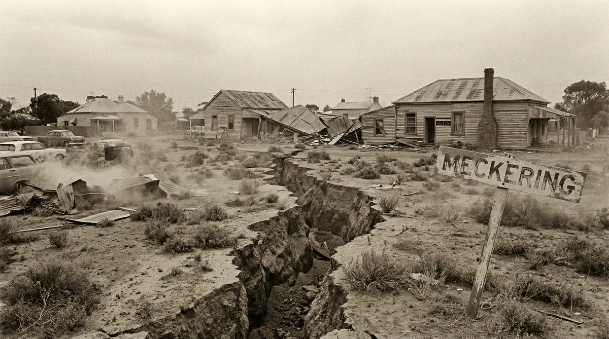
At 10:59 AM on 14 October 1968, a magnitude 6.9 earthquake struck 130 km east of Perth, near the small wheat-belt town of Meckering, Western Australia. The earthquake produced the longest surface fault rupture ever recorded in Australia — a 37 km scarp that in places reached 1.5 metres in vertical displacement.
The town of Meckering was almost completely destroyed. Of the 60 buildings in the town, 55 were either demolished or rendered uninhabitable. Remarkably, only one person died — a woman who suffered a heart attack during the shaking. The low casualty count was due to the sparse population of the wheat-belt and the fact that most residents were outdoors at the time.
The Yilgarn Craton: Ancient and Seismically Active
Meckering sits on the Yilgarn Craton, one of the world's oldest and most stable pieces of continental crust, formed approximately 2.5–3.7 billion years ago during the Archaean eon. The Yilgarn Craton is a rigid, cold block of rock that has not been significantly deformed since its formation — conditions that might suggest low seismic risk.
In fact, the opposite is true. The rigidity and coldness of ancient cratons means that seismic energy is transmitted with very little attenuation. An earthquake on the Yilgarn Craton can be felt over an area 5–10 times larger than an equivalent earthquake in a younger, warmer tectonic setting. The Meckering earthquake was felt across virtually all of Western Australia and in parts of South Australia.
The seismicity of the Yilgarn Craton is driven by the compressive stress field of the Indo-Australian plate, which is being pushed northward by seafloor spreading in the Indian Ocean. This compression is accommodated by reverse faulting on pre-existing structures within the craton — structures that may be hundreds of millions of years old but are reactivated by the current stress field.
The Surface Rupture
The most remarkable feature of the Meckering earthquake was the surface fault rupture — a visible crack in the Earth's surface extending 37 km in a roughly north-south direction. The scarp had a maximum vertical displacement of 1.5 m and a maximum horizontal displacement of 0.8 m, indicating a predominantly reverse (thrust) faulting mechanism.
Surface rupture is relatively rare in Australian earthquakes. Most Australian earthquakes occur on blind faults — faults that do not reach the surface. The Meckering rupture was therefore scientifically significant, providing the first direct evidence of active faulting in the Yilgarn Craton and establishing that the region's seismic hazard was real and ongoing.
The fault scarp is now preserved as a geological heritage site and remains visible in the landscape more than 50 years after the earthquake.
The Calingiri Earthquake: A Reminder Two Years Later
On 10 March 1970, a magnitude 5.9 earthquake struck near Calingiri, approximately 60 km north of Meckering. The Calingiri earthquake also produced a surface rupture, approximately 3.3 km long, and caused significant damage to buildings in the town. No fatalities occurred.
The two earthquakes within two years in the same region confirmed that the Yilgarn Craton was seismically active and that the Meckering event was not an isolated anomaly. Together, they established the south-west of Western Australia as the highest seismic hazard region in Australia — a designation reflected in the current AS 1170.4 hazard map.
Implications for Western Australian Construction
The Meckering and Calingiri earthquakes have direct implications for building design in Western Australia:
Perth and the south-west have the highest seismic hazard factor (Z) in Australia. Under AS 1170.4:2007, Perth has a Z value of 0.09g — higher than Sydney (0.08g) and Melbourne (0.08g), and significantly higher than Brisbane (0.06g). Some parts of the south-west wheat-belt have Z values up to 0.12g.
Unreinforced masonry is particularly vulnerable. The Meckering earthquake demonstrated the vulnerability of unreinforced brick masonry — the dominant construction type in the wheat-belt towns. Modern AS 1170.4 compliance requires either reinforced masonry or structural framing in seismic zones.
Surface rupture is a real hazard. In areas with known active faults, setback requirements from fault traces are an important design consideration. The Meckering fault trace is mapped and should be considered in any development in its vicinity.
The 2016 Petermann Earthquake: History Repeating
On 20 May 2016, a magnitude 6.1 earthquake struck the Petermann Ranges in the Northern Territory, approximately 150 km south-west of Alice Springs. The earthquake produced a 21 km surface rupture with up to 1.5 m of vertical displacement — remarkably similar to the Meckering event nearly 50 years earlier.
The Petermann earthquake occurred in a region with no historical seismicity and no mapped active faults. It was a stark reminder that Australia's seismic hazard is not fully characterised by the historical record, and that significant earthquakes can occur in unexpected locations.
Sources: Geoscience Australia earthquake catalogue; Gordon (1971) "The Meckering and Calingiri Earthquakes"; Clark et al. (2017) "The 2016 Mw 6.1 Petermann earthquake"; AS 1170.4:2007.